|
A ceremony to dedicate the Potawatomi Trail of Death Regional Historic Trail historic highway signs was held June 5, 2010, at 1:30 p.m. at the sign at the north edge of Tippecanoe County. To reach this sign from Americus on SR 25, turn north on Grant Road and go 2.25 miles north to the intersection of CR 950 N. The public is invited. After the dedication, a caravan will drive to the other PTD signs across Tippecanoe County. Those interested may meet and eat lunch with the Potawatomi at 11:30 at TC’s restaurant in Battle Ground, located at 109 N. Railroad Street. The signs were sponsored by donations from the following: Most Rev. William L. Higi in memory of Father Benjamin M. Petit, Catholic priest who traveled with the Potawatomi to Kansas; Janice Harris, Marsha Selmer, John & Carolyn Shippee, Tracy and Erin Locke, Indiana Veterans Home, Friends of Tippecanoe County Public Library - all of Lafayette; John and Nancy Maylath, W. Lafayette; Kitty Dye, Naperville, Ill.; Mary and Scott Brady, Logansport. Thanks to Indiana Highway Dept., Battle Ground Street Dept. and Tippecanoe County Highway Dept. for erecting the signs and providing the posts. The installation of these historic highway signs completes the marking of the Potawatomi Trail of Death in Indiana. Other counties on the Trail of Death are Marshall, Fulton, Cass, Carroll, and Warren. The signs in Tippecanoe County are a different color from the other counties because federal regulations now designate black and white as highway information. Tourist and historic signs are now required to be brown and white. All the signs have a picture of a Potawatomi family walking (father and mother with a baby on her back) led by an eagle. This drawing was created by Potawatomi artist David Anderson, Seattle, Washington. The project was spearheaded by the Potawatomi Trail of Death Assn., headed by Dr. George Godfrey, Athens, Ill., member of Citizen Potawatomi Nation and descendant of the Trail of Death; and Shirley Willard, Fulton County Historical Society, Rochester, Ind. See website www.potawatomi-tda.org. For more information contact Shirley Willard at 574-223-2352 or The purpose of this organization is to publicize the Trail of Death Regional Historic Trail, research and teach about the Removal Period, promote public and scholarly education about it, and maintain a web page with news and history. They publish two newsletters a year but operate and communicate mostly via email. Dues are $20 a year and should be mailed to PTDA, Fulton Co. Hist. Soc., 37 E 35 N, Rochester, IN 46975. The PTDA contacted all 25 counties and got historical markers erected at each campsite every 15 to 20 miles from north central Indiana to eastern Kansas, a distance of 660 miles. Over 30 of the historical markers were erected by Boy Scouts and Girl Scouts. The PTDA is accepting donations to install historic highway signs to mark the trail so that motorists, bikers and hikers can follow the route taken by the Potawatomi in 1838 when they were forcibly removed at gunpoint from their Indiana homeland. Kansas and Indiana now have the highway signs completed. A grant from the Citizen Potawatomi Nation, Shawnee, OK, helped with signs in Missouri and Kansas. A new grant from the Prairie Band Potawatomi Nation, Mayetta, Kansas, is funding signs in eastern Illinois. Potawatomi Trail of Death Regional Historic Trail highway signs in Tippecanoe County, Indiana. A PTD sign and arrow have been installed in advance of the intersection at each turn:
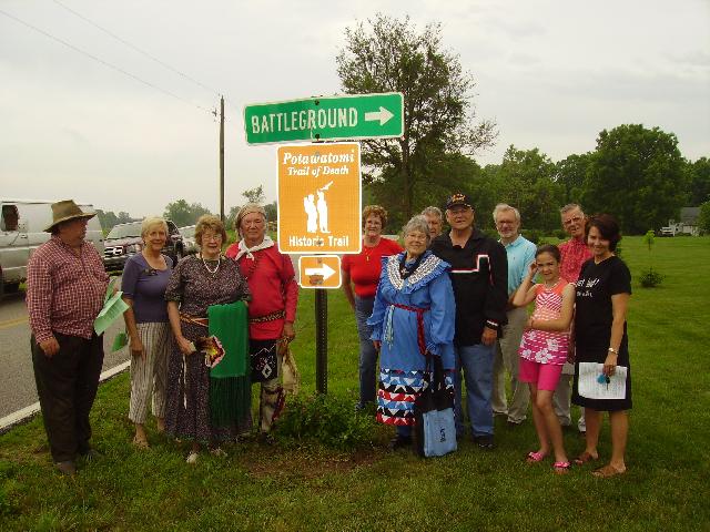 Dedication of Potawatomi Trail of Death historic highway signs June 5, 2010, at the sign at north side of Tippecanoe County on Grant Road south bound to turn on Pretty Prairie (right arrow) on the existing "Battle Ground" sign. This is about 2 miles from Americus on SR 25. From left: John Walter, Kathy Atwell of Tippecanoe County Historical Assn., Pat and George Godfrey of Citizen Potawatomi Nation, sign, Marilyn and Vince Green behind Shirley and Bill Willard, Dominick Andreami, George Wesselhoft in red shirt, Erin and Tracy Locke of Citizen Potawatomi Nation. (Photos provided by Shirley Willard.)
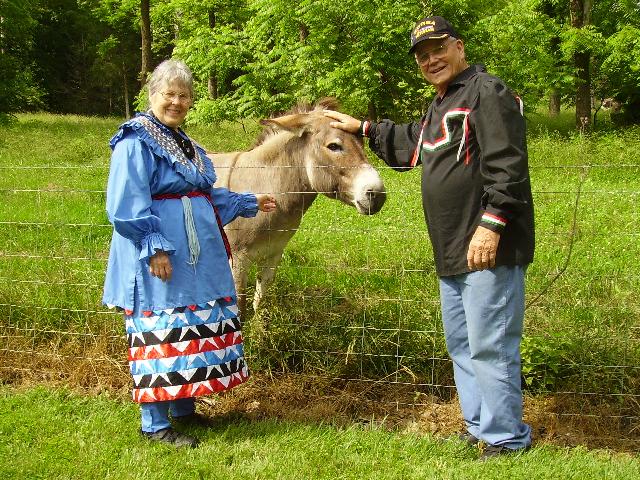 Ed Earl, the donkey, greets visitors to the last Trail of Death historical marker in Tippecanoe County. Here Shirley and Bill Willard pet him. Ed Earl has a very loud bray to greet people with. He belongs to the Jim Crites family, West Lafayette, at whose roadside the historical marker is located.
|
| < Previous | Home | Next > |