|
Battle Ground, Indiana Coming from the northeast, turn right on Pretty Prairie Road, which runs into Grant Road so turn south (right) on Grant Road. Follow Grant Road for a mile and turn west (left) on Pretty Prairie Road again and cross over the Tippecanoe River. Pretty Prairie Road becomes Main Street as you enter Battle Ground. Get on North 9th Street which goes on the north (right) side of the railroad - it takes you to the Battle Field Museum. The Trail of Death marker is a huge boulder in front of the museum. Wednesday 12th Sept. [Traveled 15 miles from Pittsburg to just past Battle Ground, Indiana.] At half past 8 o’clock we struck our tents and started on the march. At 11 we reached and forded Tippecanoe River. A little after 12 we passed the Battle Ground and at 1 we arrived at our present encampment near Battle Ground. Immediately after our arrival the Indians were collected and Dry goods consisting of cloths, blankets, calicoes, etc., to the amount of $5,469.81 were distributed among them. [A new muster roll was taken when distributing clothing, according to a letter written by John Tipton Sept. 12, 1838.] Nothing of importance occurred during the remainder of the day. The Indians appeared to be well satisfied with the distribution of the goods. A very old woman - the mother of chief We-wiss-sa - said to be upwards of 100 years old, died since coming into camp. [George Winter wrote that We-sissa’s mother was not able to continue and the family debated on whether to kill her and spare her further misery.] 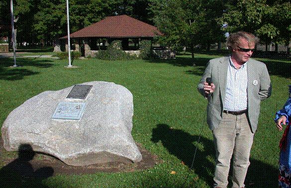
Battle Ground, Indiana - Battlefield Museum. GPS N-4030385 W-8650656. Located in front of museum beside the sidewalk. Metal plaque and corian map on boulder taken from Burnett’s Creek and hauled to Battle Field Museum by Tippecanoe County Highway Department. Erected by Girl Scout Troop 219 in 1996, led by Pat Ruhlander. The map and plaque were designed by Tom Hamilton and paid for by him and other descendants of Abram Burnett, a full blood Potawatomi who was on the Trail of Death. Pictured above is Kevin O’Brien, Director of Tippecanoe County Historical Association, beside the Trail of Death marker at Battle Field Museum. (Photo by Larry Prichard, Lynn, Indiana, on Trail of Death caravan, 2003.) 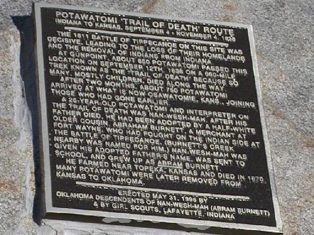 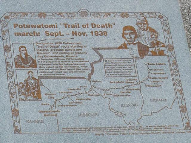
Close up of Trail of Death historical marker on huge boulder hauled from Burnett’s Creek, located in front of Battle Field Museum beside the sidewalk. The map and plaque were designed by Tom Hamilton, member of Citizen Potawatomi Nation, and paid for by him and other descendants of Abram Burnett, a full blood Potawatomi who was on the Trail of Death. (Photos by Mike Dodson, Shawnee, OK, editor of HowNiKan for Citizen Potawatomi Nation, taken on Trail of Death caravan 2003.) 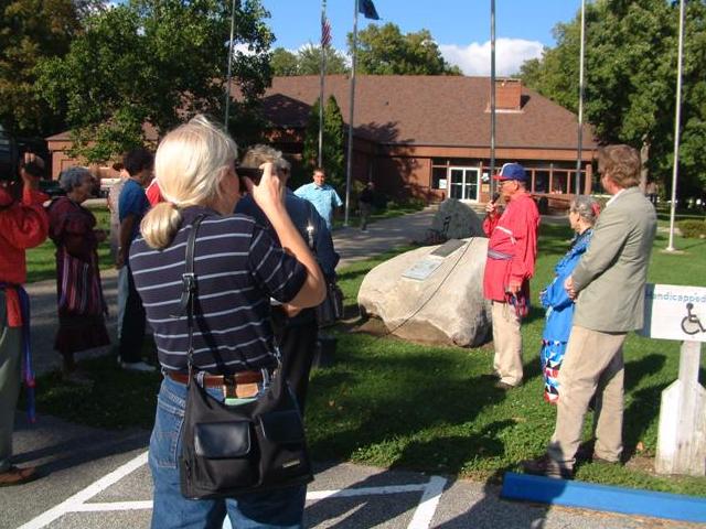 Battle Ground, Indiana - Battlefield Museum. GPS N-4030385 W-8650656.
Pictured above is George Wesselhoft, Lowell, Indiana, with the microphone. His family, descendants of Abram Burnett (Nan-wesh-mah) was a full blood Potawatomi on the Trail of Death. His cousin Tom Hamilton (in red shirt at left with video camera) spearheaded the placing of this marker. To the right of the picture is Shirley Willard, Rochester, and Kevin O’Brien, Director of Tippecanoe County Historical Assn., Lafayette. (Photo by Charles and Gretchen Meiser, Sault St Marie, Michigan, member of 2003 Trail of Death Commemorative Caravan.) |
| < Previous | Home | Next > |